What is your potential risk from wildfire? Property damage or loss? Additional financial loss due to increasing insurance rates? Both?
What can you do? One, research your location on the risk map offered by the state and take the appropriate steps. Two, join the community service provided by the Desert Preservation Initiative (DPI) in removing the wildfire fuel threat of tamarisk growing in our midst.
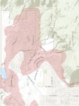
As City Council Member and Kayenta resident Wayne Pennington explains it, the state has adopted an approach “to level the playing field for insurance companies and to assist homeowners outside of the High Risk areas in being treated fairly while also being given an opportunity to reduce their risk of wildfires” by identifying the top 5% highest-risk structures for fires at the wildland-urban interface. Unfortunately, much of Kayenta is in the High Risk area.
A map at wildfirerisk.utah.gov can show you whether or not your property is in the High Risk area. The map is easy to view, and an FAQ page is very helpful.
How it will work is this: owners of structures identified as being within the top 5% will be contacted by the appropriate county office, and the owner can request an on-site assessment. If your home is in the High Risk area, insurance companies will be allowed to charge a higher rate. But the assessment will determine if you are in the “moderate” High Risk, “high” High Risk, or “extreme” High Risk. If you do not agree to have an on-site assessment, your home will default to the “extreme” category.
In addition, all new construction in Kayenta, including external additions or modifications, will be required to be built to a higher standard for hardening against fire. This will be enforced by the City of Ivins as part of its normal building permitting process.
Improvements that reduce risk to individual sites within the High Risk areas can reduce the level of High Risk for that site, but removal from the High Risk area entirely requires the effort of the community.
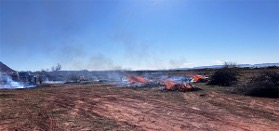
Beyond individual responsibility for lowering risk on their own property is the community’s responsibility for dealing with high fuel loads that can impact anyone and create a fire that can climb out of the washes and sweep across multiple properties. As Pennington told the attendees at the Shonto Point HOA annual meeting, “Tamarisk is the single highest risk fuel here.” If you want to make a real difference, join the Desert Preservation Initiative in its community service work tackling the large scale removal of this fuel.
“We welcome all volunteers in joining our neighbors in this important work,” says Deonne Knill, DPI president. “There are a number of ways you can contribute that should suit your interests and energy.
“If you haven’t been involved in removal before, we will offer you the appropriate training and safety instruction. If you don’t want to do the physical removal of tamarisk, we need help in other ways.
“You can join the team that monitors for tamarisk regrowth. You can join the team being formed to spearhead and implement restoration—planting and caring for native plants and trees until they are established. Or, you can bring your creative thinking to our fundraising committee as we work to cover our ongoing operating expenses. All hands are welcome.”
To volunteer, visit our website at https://www.desertpi.org/ or email admin
@desertpi.org You will find a fun, hardworking, enthusiastic group dedicated to making our beautiful environment safer for us now, and for future generations.
The pink areas show the parts of Kayenta currently identified as High Risk.